Pages

Tampilkan postingan dengan label miles. Tampilkan semua postingan

Selasa, 12 April 2016

January 26 29 Four More Lay Days in Marathon Zero Miles

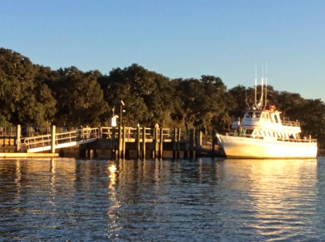
Here is a view, looking east toward the mooring field in Marathon from ILENE.
LOTS of masts. and more beyond them. A few of the boaters are at the marinas dock, a seawall.
And the marinas inner dinghy dock with lots of room. They have as much room again at the outer dinghy docks to the right at the rear end of the photo.  And they have "project rooms" where you can sew sails, varnish your oars, etc.


We had a very pleasant day with Bev, who was introduced to us by my friend, Hugh. She picked us up in her truck and drove us back to her beautiful home on Duck Key, about twelve nautical miles back east from here. Bev served us a lunch, let us do laundry and take showers, took me to Home Depot and Lene to Publix and then we had happy hour and dinner with her at the Sunset Grill, at the western end of Marathon, with great sunsets, before driving us back to our dink. It was a very full afternoon, on a day when the wind had moderated somewhat so we were not afraid to leave ILENE unattended. Bev lost her husband, suddenly, less than two years ago. They were boaters so she knows how to treat cruisers. She has five lovely grandkids in MA and in MO, where she will be moving back to soon. Bev is a pretty woman but sadly declined the offer to appear in this blog. Duck Key is an upscale residential community on an island south of Route 1, with mostly waterfront homes on the canals that run through the island. Shopping is a ten mile drive to Marathon. Sadly, we may never see you again Bev, but if you ever come to NYC and we are home, there is a berth for you.


These manatees come to the dock where there is a fresh water hose. But we are not supposed to feed them water because it encourages them to come in too close where they get hurt by propeller blades. You can see a white scar on mommas back (upper left). She is ten feet long! They are vegetarians and will not intentionally harm a human. Sort of a weird cross between a walrus head, a whales body and a beavers tail.

While at Home Depot, with a lot of help from a very knowledegable staffer, I bought all of the parts (except nuts, bolts, washers and sealant -- which I had) to install the aft, 360 degree white running light atop a length of PVC pipe.
The problem was that the base of the light had only a threaded hole for a six mm bolt. I needed to create a stub to stick into the PVC. About two hours of work the next morning in the wind sheltered inner dinghy dock area, and it is done. Until now we had to hold the white light on the top of one of our heads, which gets tiring on the arms after a while. And while I was at it, after looking at MANY other dinks at the dock, I tied a thin short line around the base of the dinks red and green bow light, with the other end secured in the boat. So when, the section cup fails, as it will, the $35 light will fall into the boat rather than into the sea.

Then we met Alex, proprietor of SeaTek. He had come recommended by John and Marcia of s/v Remora. A very pleasant and efficient young man with a beard who lives aboard his boat, anchored here. He advised us to visit Marquesas Key on our way to the Tortugas, and stay in an unmarked place where the water is deep enough. He is also an intelligent and inexpensive marine electrician. He came to our boat, fixed a lot of things electrical and ordered the "combiner" we need to solve our battery charging problem which he will install when we stop here on our way north. I had caused one problem when I installed the batteries: I crossed two black cables causing the Link interface to confuse the two batteries. Another problem was a fuse that took ten seconds to replace. He pointed out a poor crimp which I fixed after he left. I took the aft part of the boat apart before he got here to save time and was very pleased with how much he got accomplished in one $70 hour.

An afternoon of shuffleboard followed by Lene watching her TV shows on the Marinas wifi while I visited the Marathon YC, where, as Harlem members we are welcome to dine. They have 300 members, mostly power boats, and only 20 slips -- no moorings. Most of the members keep their boats at back yard docks in the canals. A rather unforgettable, except for presentation, dinner at Marathon Steak and Lobster rounded out our visit here.

Read More..

Senin, 11 April 2016

April 21 22 Charleston SC to Wrightsville Beach NC 155 7 Miles

We left at 10 as planned, but I screwed up reading the tide table so the tide was against us on the way out of Charleston, though weakly. We put up the main in the inner harbor and jibed it several times on the way out, past Fort Sumter where our Civil War began. Actually it began in SC, earlier, with the thinking of Calhoun, on the theory of states rights to "nullify" federal authority, a doctrine now becoming popular again among the lunatic right in this country.
We turned left as soon as we reached the first buoy after the end of the seawall and put up the genoa as well. This was before noon but the wind was too weak and too far behind us, to move the boat with  any speed, so we motor sailed, mostly motored, until about 1:30. I even had taken down the mainsail. I had not realized how much of the first 109 mile long part of this passage, was more easterly than northerly and so the projected five to ten knots of west wind was behind us. Then came wind, much stronger than projected and a gift to us. I was able to get up half the mainsail, with double reef in it, and continued with the genoa. The wind built behind us and we were screaming along at seven to eight knots with peaks at 8.9. And with the wind about 120 to 150 degrees from our bow, we rolled a lot from side to side, most unpleasant. Lene felt a bit nauseous though she did not lose her food. We had a delicious cold dinner -- no cooking with the rolling. It was warm and sunny by day and reasonably warm at night, with no rain. But during the night we got some slow speeds, less than four knots and even though I did not put up the genoa again until near daybreak, it was this night part, as well as the first few hours, where we lost time
After dinner, at 7:30, we replaced the genoa with the small jib, a safety measure for nightime sailing in big waves, and were still making over seven knots with just the small headsail and double reefed main. We had put on the preventer to prevent accidental jibe of the mainsail, and with the small jib sliding back and forth we took it in and sailed under just double reefed main. The preventer was a good thing because the wind had shifted from off our starboard quarter, to off the port quarter during Lenes watch. We were sailing "by the lee" -- the way you get that accidental jibe. When I got up at one (Lene let me sleep late) we jibed the main and continued on toward the turning point - off the tip of Frying Pan Shoals, which extend many miles out into the Atlantic from the Cape Fear River. We saw very little traffic: Two big freighters passed us at quite respectable distances -- closest point of approach being miles away -- and one sailboat overtook us, headed for Beaufort. I saw his lights and estimate he was 200 yards off our starboard side, moving a fraction of a knot faster than ILENE. Prior to the close passage I had a radio conversation with him to confirm what each of us was going to do.
Once around Frying Pan, at about 4 to 5 am, we turned north to Wrightsville (The Masonboro Inlet) and the wind came up from our port quarter to its beam and even forward of that. This second leg was only 32 miles and wind speed varied considerably during the leg, as, consequently, did boat speed.
It is hard to get good pictures of a night passage so at least I have the long awaited dawn.

Masonboro Inlet is easy, wide, well marked and flanked with seawalls. Once in, it is easy to get to the anchorage area and we dropped at 1:30, only 90 minutes "late" compared to our projected schedule that would have averaged 6.5 knots. Nice homes line the bay side of the barrier island.
We put out a lot of chain because there is lots of room and 20 knots were predicted for this evening. But by 4 pm it was howling at up to 40. We visited Wrightsville and made the reciprocal of this same ocean passage, to Charleston on our way south last fall and hence felt no need to lower and raise the dink to stretch our legs in Wrightsville. Tomorrow: Beaufort NC, about 80 miles and if the forecast comes true, a beam reach  or close reach from the port side, with five to fifteen knots.
I  tried to take a photo of the pod of dolphins playing under and around our bow, taking the Ipad up there, but they are way faster than ILENE at eight knots. I took maybe 50 shots and only one, a video of less than one second, caught a dolphin. These were not the slow graceful swimmers in the ICW but racers amidst the big ocean waves. I couldnt get the video into this post but it is on Facebook. I did manage to neither fall off the boat nor drop the camera.
Ilene is a true member of this crew and a solid citizen on overnight passages. She grumbles a bit and still relies on me, and I have to admit I like the  second part of that. She is even taking an interest in the charts, tides and weather. I couldnt make this trip without her, physically, mentally or emotionally. We have some chores that each of us do most of, but both of us do many of the chores. She said she liked our 25.5 hours together.
On our honeymoon on the old ILENE, in August 2002, we spent a pretty terrible 36 hours in a noreaster off the coast of Maine  The boat got beat up (torn sail, water inside through the dorades, compass light out) and we got beat up too. After a good nights sleep Lene asked, "Where do we go next?"  I replied "God, I married the right woman!"  And that has become truer with each passing year.
Read More..

Minggu, 10 April 2016

December 11 13 Daytona Beach to New Smyrna and Two Lay Days There Only 16 Miles

It took only three hours with a fifteen minute delay at a bridge near our destination that opens only every twenty minutes. Cold but clear with more wind than yesterday so we used only the small jib. We passed the Ponce de Leon Inlet with its distinctive lighthouse by the sea.
There were alternate buoyed routes at two points in this short passage and we took the one officially marked as the "ICW route" which was inland from the light. The last time I was here was crewing on a northbound 74 foot motor yacht, m/v "Sea Leaf," in 2012. Then we stopped at a marina by the light before jumping out into the Atlantic for a romp up to Beaufort NC.
Today we could have gone another 32 miles to Titusville, but we broke the trip there from Daytona into two parts by stopping here because Lene heard or read that New Smyrna is a nice town.  This has emerged as our plan for the winter: We are going south in Florida slowly. We are already in Florida but have several hundred miles to get to the Dry Tortugas, which is as far as one can go in the U.S.  This involves a lot of the ICW because many of the ports are not easily accessible from the sea. The two hops from Lake Worth to Fort Lauderdale and from there to Miami Beach, will be out in the Atlantic, during good weather, because of bridges. There are so many bridges that you have to wait for in the first such hop and a fixed 56 foot bridge in the second that we just can not ever get under. And the trip in the Keys is planned as a mix of inside and outside jumps. Having stopped almost everywhere in Florida on our way south, we plan to skip a lot of these same stops on the way north by going outside. A plan that has sort of come to us and like all plans is waiting to be changed.
Anyway New Smyrna is a very nice cozy well run, friendly municipal marina with good showers but mediocre wifi.

We are at the furthest out slip, which, given how small this place is, was not a disadvantage. In fact it was an advantage because we had a clear unobstructed view of the Christmas Parade of lighted boats on Saturday night from our cockpit. About 20 boats, both power and sail, decked out in vastly colorful lights came up the ICW right past our cockpit. The photos do not do the spectacle justice.
They have a decent history museum here run by the historical society with interesting local artifacts such as the equipment used to cut "cats faces" (shallow "V" shaped slashes) on pine trees to collect the sap to make turpentine. The town got its name from the home town of the founders wife in Greece. The Marina is in the background, two blocks from the museum and between them is a 20 foot high plateau
on which is the ruins of the foundation of either the home that was shelled and burned in a naval bombardment from two US gunboats during the Civil War or a fort. The signage was more directed against vandalism than providing information. The museum has a copy (or original of an affidavit signed by a survivor, after the war, in support of a claim for reparations, asserting that no member of the family lifted arms in support of the Confederacy. I was interested in how the legal form of the affidavit has been relatively unchanged from then to today.
One thing I forgot to report from the museums in St. Augustine is that during the civil war, excluding the native Americans, the total population of Florida was less than 10,000, more than half of them slaves. But you cant believe all you learn in museums: In Fernandina I was told that the original native Americans here were a peaceable and matriarchal society; in St Augustine the story was about the chiefs and the wars between them. Because we can not talk to them directly anymore, each historian draws his or her own conclusions.
The main drag on this half of town, west of the ICW, is called Canal Street,


about six blocks long. We had dinner one night at Yellow Dog Eats on that street, which specializes in variations on pulled pawk. Saturday the street was closed for an antique and classic car show. My friend Jim would have loved the car show. Meticulously maintained and highly shined cars from the 30s through the 70s simply parked on the street, with their owners in lawn chairs nearby to answer questions. Some pride themselves on all original components while others have replaced the interior mechanicals with more powerful and efficient engines.
We took the shuttle bus that picked us up at the far end of Canal Street at Dixie Highway and took us to the beach.
The fare is $0.75 one way for a senior. After a stroll on the beach, we walked the two plus miles back through the main drag of the beach side of town, Flagler Street, and across the bridge that detained us on our passage into town.


Read More..

February 15 17 Marathon to Rodriquez Key to Hurricane Harbor on Key Biscayne and Lay DayThere 46 4 and 47 4 Miles

Well the good news is that I did not screw up the screw -- i.e., the transmission still turns the propeller. But the bad news is that the rattle is still there. I guess its time to have a professional take a look. And with all the contortionism required to muscle bolts with wrenches in a terribly cramped space, I got a back pain though it was a little better the second day and gone the third. Its just that so many tasks require throwing your weight into it or reaching or bending -- everything except typing a blog -- that one notices such pains. But ibuprofen helps.

And I started the first day with a mistake, though not a harmful one. I recalled that some of the three passage days from Biscayne Bay to Key West were 20-25 mile days and others were 40-50 mile days, but I guessed wrong on the trip to Rodriguez and we lallygaged about and made a late start at 8:45 for what was a longer day, arriving after five. Some of the trip was good sailing, some motor sailing and during the last hour and a half the wind was directly in our faces and rather than tack back and forth we furled all sails and just motored slowly. We were passed by a boat. I could not read the boat name because it is in a fancy script- more later.

We anchored on the west side of Rodriguez Key; we stayed on the other side when going south;  it appeared to provide some shelter from the wind, which was quite strong.
But the oblong island is aligned from north to south and so neither side gives much protection from a wind that was mostly from the south. But we put out 110 feet of snubbed chain in ten feet of water, with plenty of room behind us. Our nearest neighbor, 100 yards away, was the unnamed boat that had passed us. I awoke from the wind at 2 a.m. and sat up worried the rest of the night in fear of dragging. The anchor alarm suggested that we had slowly dragged but in the morning light
it appears that we did not. Not a good nights sleep.

Next day after a great french toast breakfast, thanks Lene, we set off at 8 am. We gradually caught up with that boat that had passed us the day before, who had left before us. They passed us the day before because I did not want to push the engine with its rattle. But now, I saw, via the binoculars, that she was a Catalina 34 with hailing port Oriental NC. I called them on low power on channel 16, and we switched to 17 to not impede the Coast Guard: "Catalina 34 hailing from Oriental; this is the sailboat ILENE on your port quarter." I learned that their boats name was "RagTop" and they were making the same two passages as we were and planned to stay in No Name Harbor on Key Biscayne as we were. ILENE is longer and hence faster under sail. When we passed them we wished each other a good passage and said we would try to meet up in No Name. I still did not know the peoples names.

The wind was in the low 20s and on our starboard bow. It was on shore yet the waves were not large. The Keys, heading for Key Biscaye through Hawk Channel are arrayed in a curve and as we got closer we were able to gradually steer a bit more north and a bit less east so the wind came from near close hauled to near our beam. We had full main and small jib and were heeled quite a bit,
though Witty wasnt upset by it.  We were doing near seven knots on average the whole way up Hawk passage and hit eight for a few minutes. We could probably have gone faster with less heeling if we had reefed the main but the forecast called for 10 to 20, not 20 to 25.
 We accomplished  in one day the mileage that  took us two days on the way south, going directly between Rodriquez Key and Biscayne Bay without the stop at Pumpkin Key. This was in part due to the free open speedy passage in Hawk Channel and was necessitated by the fact that we passed the entrance to Angelfish Creek way before high tide and waves were pushing on shore there. We entered through Biscayne Channel which is wide, deep and well marked.
Still with the wind and waves and tide all pushing us in, and never having been there before, and with the course involving some jibes, and channels always looking narrower on the charts than in real life, we dropped the main before entering and used the small jib, the tide and the engine at low rpms to make 5 to six knots on the way in. The channel is marked by 20 day marks and several fishing camps, houses built on stilts, on its sides. You can occasionally see shoals that line the sides, but mostly they are under water so you cant see them; it was like Boca Grande. Once through the channel into Biscayne Bay, we turned to starboard for No Name Harbor, which the book says is horribly overcrowded on weekends. This was Presidents Day and it was quite overcrowded, so we went to Hurricane Harbor, where the entrance was shallow, 62" at mid tide, but it quite deep enough at fifteen feet once inside.
And there was plenty of room for ten boats with only three present. I called RagTop and told them we were in Hurricane and they were anchoring outside of No Name due to the crowd so I suggested that they come over. There are NO waves in Huricane Harbor and precious little wind. The advantage of No Name is that though they charge you $20, they have a dinghy dock, restaurants and access to beaches etc. This harbor is completely surrounded by private homes.

and there is no shore access at their private docks, but we do not need shore access every day. In the second photo, on the right, through the harbor entrance, you can see the skyline of Coconut Grove, about four miles across Biscayne Bay.

Our neighbors here have left us alone, which is better than some of Floridas wealthy waterfront land owners have behaved. We exercise our legal right to anchor, for free, in the navigable waters of the USA and do no harm. And ILENE is a pretty boat, at least in our opinion and enhances their view. But some have tried to use legal means and sheer harassment to exclude boats from the waters near them. They dont own the water but they like to think they do. One guy moored a fleet of his own small faux miniboats in front of his house to "use up" all the available space. The idiot spoiled his own view with those ugly things.

When they had anchored we invited  Rag Top for wine and thereby finally learned their names: Don and Trish. They live four hours inland by car from Oriental, and this is their first extended cruise. They were part of a rally of new cruisers who went from Hampton VA to Florida, sort of like the Caribbean 1500, but via the ICW, so they partied most nights.  They are pretty good sailors in that they only gave a few tenths of a knot to ILENE. We enjoyed talking with them about cruising and boats in general.

The lay day was devoted to cleaning, -- the spots that we dont get to very often. Benny of s/v ""Rhianna", who we met in Beaufort SC, alerted to our nearness by Dean, of s/v Autumn Born, called and we might meet up with them soon. Three of four boats came into this harbor during the day but left within hours. We were also very close to Bob and Brenda of s/v "Pandora", which I helped sail from Essex CT to Annapolis in September. Our last night in Hurricane they were in No Name, only a mile away. Now back to Miami Beach where we have guests coming from NYC.
Read More..

Kamis, 07 April 2016

October 24 Yorktown to Portsmouth 43 Miles

We were underway from 9:15 to 4 pm, and under sail except for the first ten minutes and the last hour after the wind died. This was quite a contrast from when we made the reciprocal passage in late may or early June 2012 when we had no wind at all. We went from a deep broad starboard reach to a more beamy port reach after the jibe, out in the Bay.
But first we were approached, fast, by an orange machine gun toting RIB. The Coasties aboard told us, politely,  that we must keep 500 yards distant from a vessel they were escorting. We barely saw it at first,  but it came up on our starboard beam with another orange dinghy escort.
Other VHF announcements to the world from the Coast Guard said that they would use force, including the possibility of deadly force, on  any vessel that got too close.

It was a clear cold brisk day out on the Bay. Lene resorted to MANY layers; me, a few less of them. we crossed a lot of water on banks that had depth in the teens before entering the deep water of Hampton Roads and later, the Elizabeth River, which divides Portsmouth from Norfolk. The Roads was the site of the battle of the Monitor and the Merrimac.  This big guy passed us,
going slowly out. We were properly outside the channel, but not far enough outside to make Lene happy.


The water is deep here virtually wall to wall. And this area remains a center of Naval activity. We expected to see these guys,
but not the Battleship Wisconsin, which I had thought had been retired long ago. Note the nine huge 16 " diameter guns, each capable of hurling a one ton projectile 20 miles.

Once out of the Bay -- yes we are now south of Chesapeake Bay -- despite shaking out the reef and switching to the Genoa, we did not have enough wind and hence resorted to motoring.  We took the free dock by the Renaissance Hotel. No water, no electricity, no hands to help us with our lines -- you just get what it says, a free dock for the night - the same spot in which we spent two nights in 2012. It is across a little basin from the ferry that will run you over to Norfolk for $4 round trip. Luckily that noise and the resulting wakes stop at night.

Lene made a perfect landing and I rigged up the fender board to keep us off the pilings. We took a short stroll through town on Lenes successful search for coffee and met up with folks from four boats that are traveling together, and, since the canal is narrow here, with fixed times for lock openings they will be with us as well.  Back to our boat for a good home cooked meal. Here is Norfolk, across the river from our boat.


Read More..

HYC Cruise Day 1 July 25 City island to Port Jefferson on Long Island 39 Miles

Every cruise  has some boats that try as they might, just cant make it for mechanical or personal reasons. This year, so far, it has been Paul and Mary on "Little Jumps", a victim of the press of business. I use to be a slave to the law so I know. We will miss you.

The day was warm and sunny; well you know, pretty much the same as back in Eastchester Bay.

Mark and Marsha of "Leeds the Way",  spent Friday night in Oyster Bay to make a shorter sail today. They got to the mooring field of the Seatauket YC in the 2 to 2:30 time frame. As did "True North" who motored from the Harlem.

ILENE, left the HYC mooring field at 7:30 in a dead calm and put up the main for almost the whole way and one or the other or parts of both headsails for most of the way -- after a bit of wind stirred the surface of the water. So we motor sailed almost the whole way. The problem was that the wind was from the east, where all the boats were heading. Motor sailing took us from Huntington, Long Island to Norwalk, CT and back across the Sound again to Port Jeff, arriving a bit after three.

And thats why Leeds the Way and ILENE were the only ones able to enjoy the wonderful cocktail party that True North hosted, starting at 5 pm.
PC Mark, Marcia, Lene, Diane and PC Bruce. Im the photographer and I kinda like the diagonal of the heads though this was purely accidental.

But we three were not the only Harlem boats here in Port Jeff. The rest just arrived too late for the party: PC Ernie and Camille and their guests, pc Marty and Ghenie, on "Blast", Dan and Mary Jane on " Tively II" and CJ and Jenny on "Shanghai" (who sailed with us and the Hermione on the Fourth of July).

Shanghai wins todays award for most intrepid sailing, not motor sailing but sailing. They had a long day.

Tomorrow, Leeds the Way and Tively IIs schedules require them to turn back but the armada is headed for a two night stay in Mattituck, LI. Unfortunately, ILENE will be there with them for only the second night. A funeral for a dear friends son means we will spend Sunday in a rental car, catching up with the fleet on Monday.
Read More..

May 12 13 Last Two Lay Days in Washington No miles

No, not a Maritime Museum. This is one of the fishing boats used by the Danes in WWII to smuggle most of their 7000 Jews into neutral Sweden. It is one of the many artifacts in the United States Holocaust Memorial Museum.
I spent a whole day (10 to 5:15) here and did not see it all. Designed of the same beautiful pale yellow stone that is used in most other government buildings in this city, the interior has a long atrium around which the horrible history unfolds, as one starts on the fourth floor and works ones way down. This atrium is glass covered and reminded me of a railroad station  -- such an integral part of the Germans "Final Solution". I have been to such museums in NY, Jerusalem and smaller ones in many other cities but none that were as comprehensive, with a significant slant on US responses before, during and after the war. It showed how gradually Hitler came to power, consolidated his power and set to work first trying to drive the Jews out by making life unbearable and dangerous, then deporting them and finally, exterminating them. One huge wall of etched glass, has the names of the numerous European towns where Jews lived before Hitler, including my fathers birthplace, Untergrombach, middle row, right, with my imagined "RR Station" below.
The place was very crowded with lots of high school kids who were very respectful. I was quite moved by the experience. The museum repeatedly discussed the plight of the Roma (gypsies) and other victims. It also had exhibits on the three post-Holocaust genocides: Cambodias killing fields, the Serbo-Croation conflict and Rwanda. It seems humanity has not learned yet, despite the saying "Never Again! We had lunch in the museums cafe, located in a small building outside the Memorial.
Our final day was for Congress and the Library of Congress. We had planned to visit the adjacent Supreme Court as well. I had to be admitted to its Bar to oppose a Petition for Certiorari  in the late 70s. (Since about 95 to 99 percent of such petitions are denied, winning that one was rather easy.) But our tourism stamina gave out before we got there, which was a shame because Lene has never been there. On our way we passed the Frances Perkins Department of Labor Building.
Ms. Perkins was one of FDRs "brain trust" and the first female Secretary of Labor. She co-taught a seminar in labor history I took at Cornell in about 1964.
In 2008 Congress opened a huge underground entrance, visitors center, "Emancipation Hall," with Museum, gift shops, a large cafeteria and many restrooms to handle the throngs of tourists. We were shown an inspirational movie about how well Congress works, which is somewhat of a joke given todays hyperpartisanship. Leah, our assigned
tour guide was energetic and bright with the kids but the tour did not include either house of the Congress. We easily secured a pass to visit the House, which was in session, but just barely. The person acting as speaker recognized a stream of Representatives who rose to give speeches of up to four minutes. It was mostly women in red suits on the Democratic side and men in blue suits on the other side. Several democrats spoke in favor of refinancing the Highway Trust Fund and opposing yet-another bill to restrict abortion, which the Republicans are addicted to and will undoubtedly pass. The Republicans spoke in favor of the anti-abortion bill and in memory of slain police officers. They all spoke to an almost empty room. The speeches go into the Congressional Record and are fodder for the folks back home. "See how I represented your interests!"
After lunch we visited the Library of Congress through an underground tunnel which avoids having to go through security again. Our first time here.


The entrance hall reminded me of The Hermitage in St. Petersberg, with its staircase, marble, red, statuary and grandeur.


The main reading room is much smaller than the one in NY but more elegant.
A highlight of my stay here was a visit to the Geography and Map division, where I was given access to their collection of nautical charts published by the United States Navys  Hydrographic Office from about 1850 to 1950. The charts are numbered, to about 6500, with some omissions. I have been studying them and cataloging them, as a volunteer in the Map Room of the NY Public Library for about seven years now. They describe the coastlines of the world (excluding the U.S. and the Philippines which are the subject of a similar series of charts published by the Coast Guard. Each branch of the armed forces had its champions in Congress and back in the 19th century they worked out this geographic compromise.)  I had a good conversation with the director of the map room who invited me back. Maybe, by land, some day.
I also saw a German antiquarian map of the world, in Latin, published a few decades after 1492, purchased for $11,000,000 (less than half of it taxpayer dollars), an exhibition of Herblock political cartoons, and a recreation of Thomas Jeffersons circular library of Monticello (he sold it to the government) with mostly his original books. He was a well read man.
Read More..

Selasa, 05 April 2016

November 28 29 St Marys to Cumberland Island and Lay Day There 6 5 Miles

Another short passage, though made longer because Lene had to go grocery shopping again, her fourth day in a row! So we did not leave until early afternoon, when the tide was flooding into the St. Marys River, reducing our speed. Once we arrived and the anchor was securely set, some course plotting for the stops between here and Fort Lauderdale, a good dinner and we snuggled in for a night that was supposed to be even colder than the one before, but wasnt. While I played with the charts, Lene checked out Cumberland Island by trhe internet. It is a "National Seashore" administered by the National Parks Service. Im grateful to Dick and Elle for suggesting Cumberland as a great place to stop and to Lene who found the activities on the island. It is very roughly the size of Manhattan Island and we passed its beachy Atlantic coastal side while heading south for the St. Marys River inlet about a week ago. Our anchoring location was on its east coast, just off "Sea Camp", the NPS ferry dock,
Dinghy left, ILENE, right


where small boatloads of passengers come over from St. Marys, twice a day, to mingle with folks like us who come on our own bottoms.
All the tourists are also divided among those, like us, who spend a day (or less) on the island and those who bring tents, food, water etc., and camp out at its camp sites, by permit, for up to a week, $4.00 per head! The campers can be further divided between those who take campsites less than a mile from the dock, and those who carry all their stuff up to eleven miles (and back) to camp at wilderness sites.The eight folks here came as a group, took the near option and very friendly.
We were fortunate to get two open spots (another couple had not been able to make it) on a guided tour for eight people in a government van for only $12 per senior.


led by NPS agent Roy

This was a six hour tour and Roy kept talking to us throughout and answering our questions about the geology, flora, fauna, history and politics of the island and the state of Georgia.  He was a great tour guide and very knowledgeable...and isnt allowed to accept gratuities!


We saw an armadillo


and more than a dozen of the 150 wild horses who inhabit this island.
They receive no food or veterinary services but live breed and die on the island and are quite unafraid of humans. They are smaller than the jumpers and hunters I know from barns and their life expectancy is half that of domesticated horses. They and the wild boar, were introduced here by the Spanish. We also saw wild turkeys and deer, close up, but without photos.
Live oaks predominate. This one  extends further to the right than shown, and as you can see, is quite wider than it is tall. They
are not harmed by the Spanish Moss that hangs from them, except to the extent that when wet, and the moss can hold up to ren times its weight in water, can break branches off the trees.. The branches can curve down to the ground and back up again, when they grow in open cleared fields, like the one pictured. Most of them are "Second Growth"; the primeval forest having been cut down to supply curved timbers for building ships like Old Ironsides, the USS Constitution, made largely of Cumberland Island live oak.
We visited the first African Baptist Church, near the north end, a very small, one room chapel in which John John F. Kennedy Jr. was married. It was also visited by President Carter, a Georgia boy.

We stopped at Plum Orchard, a huge formal house, of about 25,000 square feet, built by the widow of Andrew Carnegies brother, for one of their sons and his wife. Completed with indoor squash court and swimming pool about 112 years ago, it reminded me a bit of Downton Abbey, in terms of the social structure and activity norms of the people who lived there.


Even larger, 37,000 square feet, was the Dungeness Mansion, built by Mrs. Carnegie for herself on the ruins of the home of the former plantation owner. Her kids decided not to maintain it after her death so only the stone and bare verticals remain.
Ms. Carnegie owned about 95 percent of the island. Sadly, those kids, who never had to go to school or do any work, generally died young, of alcohol related disorders. Roy told us there were very limited fond feelings among the children for their mother.

The island is now almost entirely owned by the government but about five percent of it is held by about 25 folks with "reservations of rights", i.e., the right to exclusive control of their land until they die. Then, one by one, the government will take over and will either restore the buildings for park or administrative uses if they have historic value or raze the structures and let the wilderness take over again. One such rights holder is Carol, who like the horses, lives off the land, at the north end, and has done so for 44 years, while becoming an expert on sea turtles.
This wall is made of "tabby" which is home made "cinder blocks" molded from burned seashells, sand and water to make a cement in which unburned sea shells are embedded in lieu of gravel to make concrete.


In the morning I went back for a walk across the island to the sea. Even with light waves, you could hear the Atlantics roar from half mile away. Long board walks to avoid disturbing the very wide dunes;
except the horses tracks show that they ignore the signs.


And then there is a very wide beach. You can barely see the three NC elementary school teachers, seated, half way back to the dunes, just slightly to the right of center.

On our way back north, we hope to explore this island by bike. We loved Cumberland.

Read More..